For his environmental observation and informatics program leadership project, Ford Freyberg participated in the NASA DEVELOP National Program, which centers around addressing environmental and policy issues and providing analysis using earth observation data to inform environmental decision-making processes.
Freyberg was the lead for the Idaho wildfires team that needed to provide various government agencies a way to consider information derived from earth observations to assist their decision-making processes surrounding fire hazard mitigation.
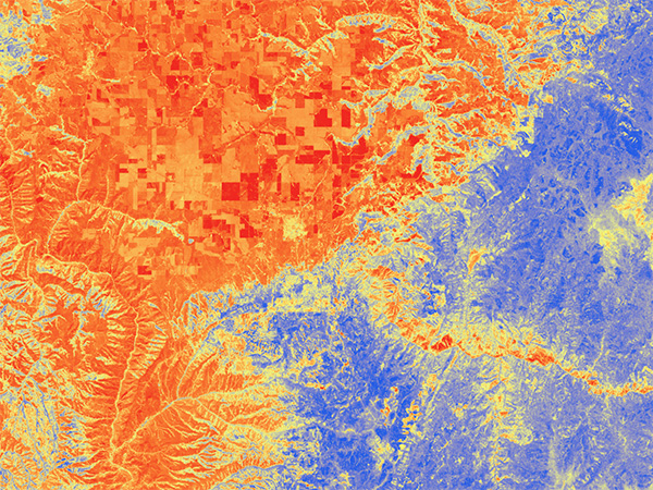
The team used GIS, Earth observation data, and other climate-related data products to assess performance of drought indicators and create maps highlighting drought and fire conditions, trends, and susceptibilities. These data, maps, and models were designed to facilitate partners’ capacities to assess drought potential and fire susceptibility moving forward by adding model flexibility, improving model performance, and incorporating a dynamic system of data acquisition and application for future years.
Project Details
Full Title
Idaho Wildfires – Assessing Drought and Fire Conditions, Trends, and Susceptibility to Inform State Mitigation Efforts and Bolster Monitoring Protocol in North Central Idaho
Deliverables
- Literature review on drought indicators and satellite image indices
- Historical analysis and visualizations of drought and wildfire as related to drought indicators
- Wildfire hazard models
Environmental Topic
Land use
Partner Organization
![]()
Skills Used in This Project
![]()
Remote sensing analysis
![]()
Maps and visualizations
![]()
Modeling
Get to Know Ford Freyberg
 Undergraduate Major
 Undergraduate Major
Biochemistry, Spanish
Current Job
Product manager, Vexcel Data Program
How did the EOI program prepare you for this project?
“I think the awesome foundation of technical skills provided by EOI allowed me to succeed in this Idaho Wildfires project in a way that would have been impossible otherwise.”
“The breadth of exposure to various remote sensing, GIS, and geospatial data platforms during the EOI program greatly facilitated my ability to accomplish tasks and goals during my DEVELOP term. I felt that EOI had prepared me well to tackle the inevitable series of challenges and frustrations inherent to working on a geospatial project of any complexity.”
“The readings and discussions on the complexities of working on teams and with people up and down the organizational ladder proved indispensable when it came to putting the technical aspects of the EOI training to use during this DEVELOP term.”
Why did you choose the EOI program?
“I was looking to transition industries but retain skills I had picked up professionally working for a software company. Finding the EOI program made me aware of the geospatial industry and sparked a desire to pursue this field. It allowed me to connect existing skills in data and software, problem solving, and professional communication with new skills and experience in geospatial analytics, coding, environmental conservation, and policy.”