What are the Issues?
Water Quality
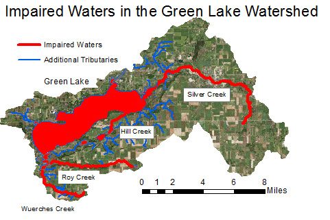
Green Lake and four of its seven major tributaries are listed as impaired waterways (Hill Creek, Roy Creek, Silver Creek and Wuerches Creek). Learn more about Wisconsin’s impaired waters. Reasons for impairment within the Green Lake watershed include low dissolved oxygen levels and degraded habitat. Contributing pollutants consist of high phosphorous and sediment levels. Search impaired waters within the Big Green Lake Watershed. Dissolved oxygen levels seasonally decline at a depth of about 10 meters within Green Lake, and in 2014, the lake was listed as impaired for low oxygen levels. The lake’s water quality issues are likely linked to nonpoint source pollution.
| Official Name | Local Name | Year Listed | Water Body Identifcation Code | Pollutant | Impairment | Priority |
|---|---|---|---|---|---|---|
| Green Lake | Green Lake (Big Green) | 2002 | 146100 | PCBs | Contaminated Fish Tissue | Low |
| Green Lake | Green Lake (Big Green) | 2014 | 146100 | Total Phosphorus | Low DO | High |
| Hill Creek | Hill Creek | 2002 | 146200 | Sediment/Total Suspended Solids | Degraded Habitat | High |
| Hill Creek | Hill Creek | 2016 | 146200 | Total Phosphorus | Degraded Biological Community | High |
| Roy Creek | Roy Creek | 2014 | 148200 | Total Phosphorus | Impairment Unknown | High |
| Roy Creek | Roy Creek | 2002 | 148200 | Sediment/Total Suspended Solids | Degraded Habitat | High |
| Silver Creek | Silver Creek | 1998 | 146800 | Sediment/Total Suspended Solids | Elevated Water Temperature, Degraded Habitat | High |
| Silver Creek | Silver Creek Mouth | 2012 | 146800 | E. coli | Recreational Restrictions – Pathogens | Low |
| Twin Lakes | Big Twin Lake | 2014 | 146500 | Total Phosphorus | Excess Algal Growth | High |
| Unnamed | Unnamed Trib to Silver Creek | 2016 | 146900 | Total Phosphorus | Degraded Biological Community | High |
| Unnamed | Wuerches Creek | 2008 | 148300 | Total Phosphorus | Low DO, Elevated Water Temperature | High |
| Unnamed | Wuerches Creek | 1998 | 148300 | Sediment/Total Suspended Solids | Degraded Habitat | High |
| Unnamed | North Tributary to Silver Creek | 2016 | 147400 | Total Phosphorus | Impairment Unknown | High |
| Unnamed | Unnamed Trib to Silver Creek | 2016 | 147700 | Total Phosphorus | Impairment Unknown | High |
Sediment and Phosphorus Loads
Current research on Green Lake’s water quality focuses on quantifying the effects of sediment inputs, phosphorus runoff, dissolved oxygen levels, and other metrics that may contribute to the lake’s impaired status. Point source and non-point source pollution from both urban and agricultural sources may contribute to Green Lake’s water quality impairments. Managers and researchers are conducting studies to more precisely identify the impact of sediment and phosphorus loads in the Green Lake watershed.
Aquatic Invasive Species (AIS)
AIS observed in Green Lake include Eurasian water milfoil, zebra mussels, curly-leaf pondweed, rusty crayfish and German carp. The introduction of these species has disrupted the Green Lake ecosystem.
What is Being Done?
In 2011, the Green Lake planning team began work on the first Lake Management Plan, which was published in January 2013. The Lake Management Plan summarizes the main issues facing Green Lake, presents research and data about the lake’s quality, and lays out strategies for mitigating these challenges. The Lake Management Plan is the framework used by Green Lake’s stakeholders when taking action to improve the quality of the lake.
The Green Lake Planning Team consists of the Green Lake Association, the Green Lake Sanitary District, the Green Lake Conservancy, Green Lake and Fond du Lac County Land and Water Conservation Departments, the cities of Green Lake and Ripon, the United States Geological Survey, and the Wisconsin Department of Natural Resources. See our partners to learn more.
Best Management Practices
Best Management Practices (BMPs) are land use practices and structures that provide favorable conditions for water quality improvement. Examples include “hard” practices, such as the installation of sediment basins, stream bank and shoreline improvements structures; and “soft” practices including no-till farming, cover crops, and terracing to prevent erosion. BMPs are critical to the Green Lake management goal of reducing phosphorus loads into the lake. Nonpoint source pollution, from both agricultural and developed areas, contributes to increased phosphorus and sediment loads reaching the lake. Working with farmers and shoreline property owners to implement BMPs that reduce runoff of phosphorus and sediment into the lake is an important goal within the watershed. Green Lake partners work with residents to educate them about BMPs, to provide funding for implementation of BMPs, and to evaluate the success of BMPs once they are implemented.
The Green Lake Association (GLA), the Green Lake Sanitary District (GLSD), Green Lake and Fond Du Lac County Land and Water Conservation Departments, the National Resource Conservation Service (NRCS), and the nonprofit contractor Golden Sands Resource Conservation and Development are all involved with BMP implementation.
Read more about BMPs in the Green Lake watershed.
Monitoring
Data collection is an important facet of lake management at Green Lake. Keeping records of stream flow, nutrient levels, plant and animal species populations, and other metrics allows lake managers to assess the state of the lake and to make decisions about future management strategies.
Education
Outreach and education are key components of the strategy to improve Green Lake’s water quality.
Because of Green Lake’s tourist industry, it is important that recreational users of the lake are informed about best practices for preventing the spread of aquatic invasive species. The Department of Natural Resources and UW Extension have teamed up to implement the Clean Boats, Clean Waters program.
Resident outreach is another focus in Green Lake, particularly around the implementation of BMPs. In the Green Lake watershed, this includes two primary resident groups: farmers and shoreline residents. The more educated and engaged residents are, the more likely they are to successfully implement BMPs. Ongoing efforts are in place by several watershed partners to create dialogue among farmers and shoreline owners and to educate residents about best practices.
The Green Lake Association provides educational resources for watershed residents, including a video tour focusing on points of interest within the watershed.