Government agencies, such as the Wisconsin Department of Natural Resources and the USGS, upload their data to online platforms. Links to these databases are provided along with a brief description for accessing data from Green Lake watershed stations.
This is an accordion element with a series of buttons that open and close related content panels.
Surface Water Data Viewer
Wisconsin DNR’s Surface Water Data Viewer is an interactive webmapping tool for physical, biological, and water chemistry data.
To find data relating to Green Lake:
- Click the “Locate and Identify” tab and select “Find Location”
- Select “Watershed” and click “Find”
- Select “Big Green Lake” and click “Find.”
This will show you a map of the Big Green Lake watershed.
To see monitoring locations, click “Show Layers” click “+” next to “Monitoring Sites & Data” Streams. Check each layer that you would like to see. On the map, you can right click each symbol to access that data and to read the metadata.
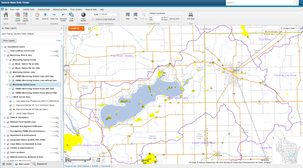
You can also search the data by specific SWIMS Station ID. Click “I want to…” and select “Find Location.” Select “SWIMS Station” and then enter the value of the station ID number. Station IDs within the watershed are also available in a spreadsheet.
SWIMS
DNR also uploads its data to Surface Water Integrated Monitoring System (SWIMS). Users need to request an ID to access data. Once signed in, you can find data by searching monitoring stations. Station ID numbers within the watershed are listed in a spreadsheet. You can also search Monitoring Stations by Watershed “UF07-Big Green Lake.” The magnifying glass next to each station will show additional information about that site. “Fieldwork Events” along the bottom will lead you to data collected at that station.
USGS
How to access USGS data for Green Lake:
Pick the station for which you would like to access data and click “More info” (make sure you can see the symbols for monitoring locations).
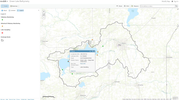
The “Available data” dropdown menu shows options for presenting data such as a summary of data collected at the site, a map of where the site is, and an interface for downloading data. “Period of record” shows duration of data collection at that site. Sampling locations within the lake, Deep Hole (West End) and East End, both show records for water samples taken at various depths. Tributary data (stations Silver Creek at Spaulding Road, Roy Creek at Roy Creek Rd, and Green Lake SW inlet at CTH K) show discharge data, results from water quality samples, and calculated loads for suspended sediment and phosphorus discharge. Discharges are calculated on a daily, monthly and annual timescale. Historical data is also available for locations that were previously monitored (Green Lake Outlet, Silver Creek at County HW A, and White Creek at Spring Grove Rd). Follow these instructions for downloading data to an Excel file. The downloaded file will include an explanation of parameter codes and data from the specified time period.
WDNR
This is a comprehensive Microsoft Access database of monitoring data that has been submitted to DNR from within the Green Lake Watershed over the past 40 years. It includes data on water quality, herbicide concentration monitoring, pathogen monitoring, aquatic invasive species detection, and macroinvertebrate (insect) data. This dataset contains information collected through DNR programs such as Citizen Lake Monitoring and Clean Boats, Clean Waters. It also includes data submitted to DNR from other agencies such as the Green Lake Sanitary District and US Geological Survey. This information may also be available through SWIMS, Surface Water Data Viewer, and the Water Quality Port. This file has data updated through July 2016. Download »
Water Quality Portal
The Water Quality Portal is a national database containing data collected by Wisconsin DNR and USGS. Searching by Green Lake and Fond du Lac counties in Wisconsin and selecting “show sites on map” produces all sampling locations within those counties. Data can be downloaded for all of the sites or individually by clicking on the site. Specific site locations can be searched by “Site ID” which is WIDNR_WQX-“station ID.” 2016 station IDs within the Green Lake watershed are listed in a spreadsheet. The portal does not include all of the DNR data.