The Green Lake Watershed Information System is a database containing information about Wisconsin’s Green Lake. It is intended to provide a clearinghouse for Green Lake data for both stakeholders within the Green Lake community and academic researchers elsewhere. This resource was developed by the Nelson Institute for Environmental Studies to enhance research, education, and management within the watershed.
Explore the Green Lake Watershed Information System
About the Watershed

The Green Lake watershed covers 107 square miles: 58.4% of the watershed in Green Lake County, 40.7% in Fond du Lac County, and 0.8% in Winnebago County. The predominant landuse within the watershed is agriculture. According to national land cover data from 2011, just over 60% of the watershed is agriculture and just under 10% is developed. Developed areas are concentrated around the cities of Green Lake and Ripon. The remaining 30% is open water, wetlands, and forest or other vegetation.
Green Lake is the deepest natural inland lake in Wisconsin, with a maximum depth of 236 feet and an average depth of 100 feet. The lake is 7.3 miles long and 2 miles wide.
The Green Lake watershed contains 141 miles of rivers, 655 acres of lakes, and 5,102 acres of wetlands. Green Lake’s tributaries are Dakin Creek, Hill Creek, Roy Creek, Wuerches Creek, White Creek, Silver Creek, Spring Creek, and Assemble Creek. Green Lake drains into the Puchyan River though a constructed dam in the City of Green Lake.
What is a Watershed?

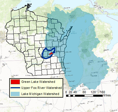
A watershed is the land area that drains to a common waterway, such as a stream, lake, wetland, aquifer, or ocean. Watersheds are also known as “drainage basins” or “catchments.” All streams, precipitation, and runoff within a watershed flow towards the common waterway. Often, a large watershed will contain several smaller watersheds. For instance, the Big Green Lake watershed is contained within the Upper Fox River watershed. The Upper Fox River watershed is likewise nested within the Lake Michigan watershed.
All activity that occurs within a watershed, such as weather events or human activity, affects the quality of the water bodies in the watershed. Pollutants that are released anywhere in the watershed can eventually enter the waterway. It is important for residents of a watershed to be aware of their contribution to the health of their waterway. Since everyone lives in a watershed, each person impacts the health of their local waterway.