Every Pixel Tells a Story

Amintas Brandão Jr. works daily to protect and preserve his community — even though he’s thousands of miles away.

Amintas Brandão Jr.
Amintas Brandão Jr.

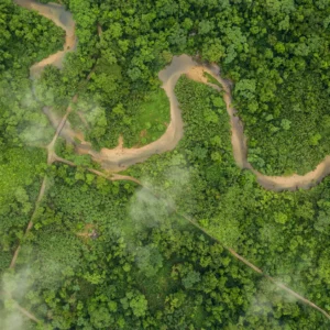
Amintas Brandão Jr. started mapping roads in the Amazon as an intern. It was 2003, and he was working at Imazon, a Brazilian nonprofit focused on conservation and sustainable development in the Amazon. For four to five hours a day, every day, he would click. Image by image, pixel by pixel, he helped shape one of the very first maps of unofficial roads in the Brazilian Amazon region — one that included every road not shown on the official maps and covered an area of approximately 1.93 million square miles.

With the available technology, it took nearly one year to accurately map the whole Amazon. But then came Google Earth, then cloud computing, and now, artificial intelligence. “One year pretty much was reduced to one week of work,” says Brandão. As Brandão’s career as a researcher in land-change science has grown, it’s done so the largest developments in conservation technology since satellites were introduced. But the crux, he argues, is the same. “Every pixel tells a story,” he says. You just have to make the connection.”

“Roads are the artery of deforestation.”  — Amintas Brandão Jr.

Brandão’s connection to the Amazon is simple: he grew up there. “I’m from the heart of the Amazon,” he says. “In the Amazon, I saw all the problems of paving of roads in my childhood.” He wanted to understand the systems and processes behind these land-use changes. While earning a bachelor’s in environmental engineering, he focused in on how technology can offer solutions to the Amazon’s environmental problems.

That’s how he linked up with Imazon and his map-building internship. His team developed a method using Landsat images  to map, for the first time, all the roads that weren’t on Brazil’s official maps. “During my time Imazon, I expanded the mapping of unofficial roads to the whole Brazilian Amazon using satellite images.” He found that more than 90 percent of the Amazon’s deforestation occurs on just five kilometers of unofficial roads. “Roads are the artery of deforestation,” he explains. He stayed at Imazon for 15 years researching that connection.

Technology was already changing, so around 2008, he came stateside for a master’s in environmental modeling from Clark University. With new knowledge and connections, he published a number of studies that investigated the impact of deforestation projects in the Amazon — including the building of the Belo Monte Dam in Altamira, where he was born.

Then in 2015 he read an interesting study. It was a landmark paper that drew the connection between deforestation in the Amazon and Brazil’s beef supply chain, and it was written by Holly Gibbs, Nelson Institute professor and director of the Global Land Use and Environment (GLUE) Lab. “I came as a PhD student to UW to start collaborating with Professor Gibbs on understanding this connection.” in 2016, Brandão entered the Nelson Institute for Environmental Studies’ environment and resources program and joined the GLUE lab.

After earning his PhD, Brandão stayed on with the Gibbs Lab and is now researcher in the group. To investigate the continual land-use changes in the Amazon, Brandão has to stay on the cutting edge of conservation, remote sensing, and satellite technology. Even though the tools have changed greatly in his lifetime, the imperative hasn’t. AI has greatly accelerated the rate at which mapping the Amazons’ roads — and thus tracking and stopping deforestation — can happen. So, what now? “These techniques — maps, tables, figures — are simply tools. Like a hammer to a nail, they serve as instruments to confront a challenge. In the end, what matters is not the tool itself, but the problem it helps us solve,” he says. “AI may sound sophisticated, but it is only a tool. The real task is to understand the problems — and the challenge lies in using AI to address them effectively.”

Waze for cattle
Part of Brandão’s PhD was the creation of a new way to connect his road mapping with cattle traceability. “You know Waze, that app?” he asks, referring to the community-driven navigation app with real-time data. “It’s kind of the Waze of cattle.” With his methodology, you can track herd flow by kilometer, which shows you whether or not the herds are coming from deforested properties. “Federal police, sanitation agencies, and other agencies could use my map in the future … to put strategic checkpoints on the roads with the more density, more flow of unofficial cattle from deforestation.”

Amintas Brandão Jr.Forging International Connections
Through his prior work at Imazon and other Brazilian connections, he helped the Gibbs Lab connect with a group of Brazilian federal prosecutors to do WHATEVER. “Nowadays, the Gibbs Lab is part of a technical working group that is giving support to these Brazilian federal prosecutors to combat the illegal deforestation in the cattle sector in the Amazon.” (In fact, one Brazilian prosecutor has since joined Brandao in seeking a degree from the Nelson Institute. Erich Masson is currently working towards his/her master’s degree in environment and resources.)

Paying it Forward
It’s been about 10 years since Brandão left Brazil —but every day since then has been spent making a direct, positive impact on the communities he calls home. In fact, that was his whole drive for earning a PhD. “I was fortunate to meet the right people throughout my career, such as Dr. Carlos Souza Jr. and Dr. Holly Gibbs, and to give back the knowledge I’ve gained by applying it to challenges that truly matter to my country.”

Threenager
Brandão’s journey to the Nelson Institute wasn’t just about furthering his own education, or even improving lives in his home country: it was to secure a limitless future for his daughter, who’s now three. “She’s a threenager,” he laughs. “I come from the textbook story of hardship — a poor country, a poor family, all of it. I’m deeply grateful that, through education, I now have the chance to give her the opportunities I never had.”