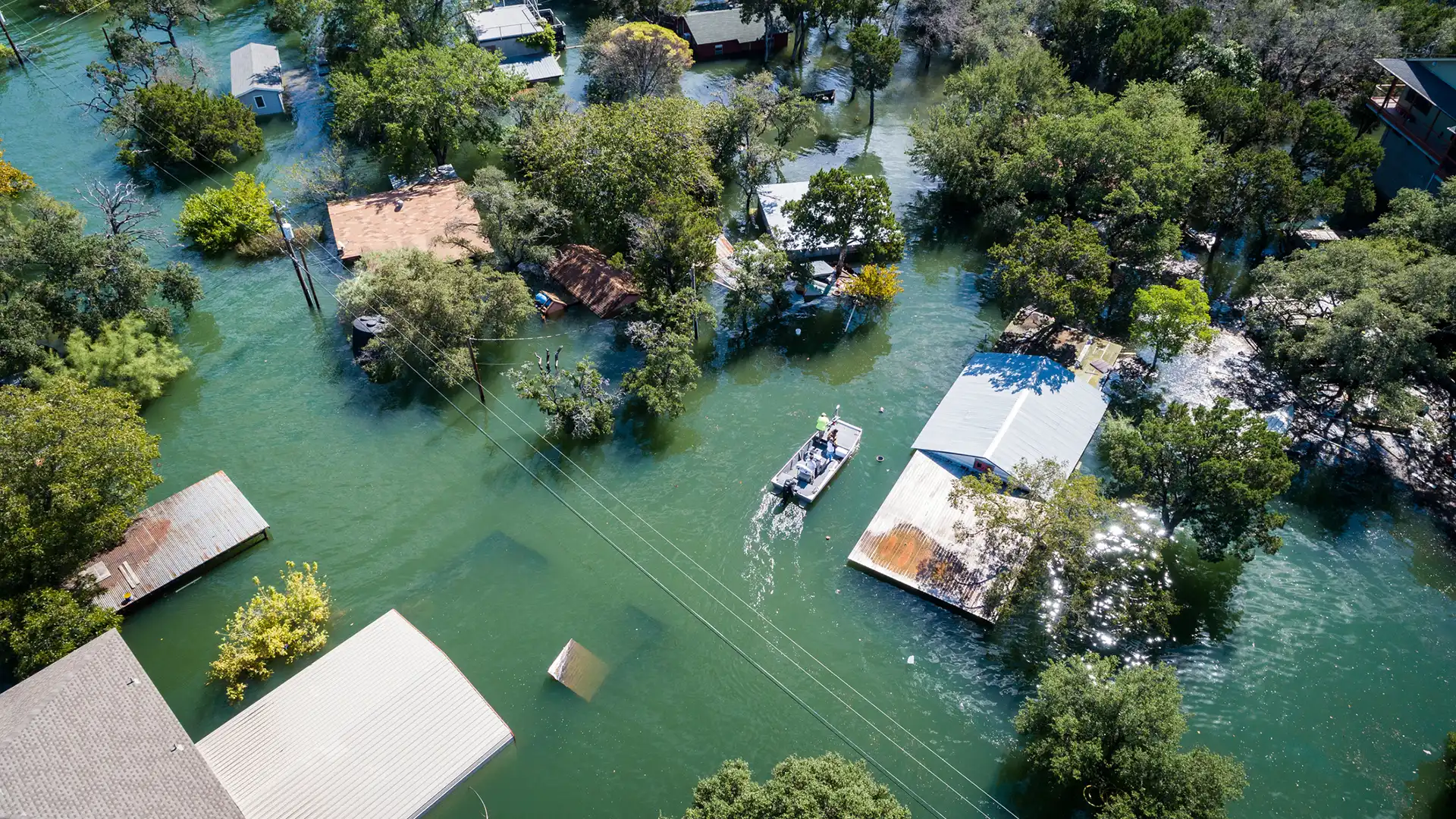

I am a flood scientist. I use satellite data to understand why deadly floods happen and what could have been different. The July 2025 flooding in central Texas was the deadliest flash flood in recent U.S. history: 135 dead, including 35 children. And this time, it wasn’t just flood scientists wondering what went wrong.
My sister-in-law asked how this could happen to her colleagues. My mom friends wanted to know why the Camp Mystic cabins weren’t evacuated. Other friends asked if their kids’ camps were in floodplains. I tried to explain. Yes, the event was forecasted. Climate change makes extreme flooding far more likely. Funding cuts to the National Weather Service strained early-warning communications. Those are explanations you can wrap your head around.
Then the New York Times reported that 19 cabins at Camp Mystic had recently been removed from official federal flood zones. That’s what’s harder to explain … and to understand. Cabins existed in a mapped floodway — a place where flood velocities are known to be high — but instead of investing in improving emergency plans or early warnings systems, engineering firms were contracted to contest FEMA’s maps to reduce insurance costs and allow expansion.
As the U.S. debates the demerits of gerrymandering and its degradation to democracy, political districts aren’t the only lines being unfairly redrawn. The Federal Emergency Management Agency (FEMA) maintains maps of areas that have a high risk of flooding. Across the country, these floodplain maps are changed every day, sometimes in ways that could hide true flood risk and put people in danger. Why? How? Do redrawn flood maps always reflect flood risk accurately, or do some paint a picture of politics, money, and power?
FEMA regulatory floodplain maps are designed to restrict development and set insurance rates. In other words, if your house is within a floodplain, your home insurance will cost more. Or if you’re a developer wanting to build an apartment complex on land in a floodplain, your building costs may be higher.

It’s possible to contest the maps through a process called Letters of Map Change, or LOMCs. If a community or property owner believes their home, building, or neighborhood shouldn’t be in a FEMA-mapped floodplain, they can contest it. That takes supporting documentation from a registered engineer to negate the FEMA map — and that costs money. Property owners can elevate the structure, infill the property, or build flood mitigation infrastructure, like a levee, and the structure can be removed from FEMA’s regulatory floodplain. These exemptions are approved almost 90 percent of time, and more than 420,000 exemptions have been granted since 1985.
Political scientists, geographers, and sociologists have found that official request of edits to FEMA maps to revise floodplain maps occur more frequently in wealthier, whiter communities. Cumulatively from 2006–19, FEMA’s changes to the regulatory floodplain resulted in a net decrease of the 1.4 million properties in the regulatory FEMA flood zone. This disproportionately affected Black and Hispanic communities and resulted in a reduction in insurance coverage in these communities.
As property owners and real estate developers initiate changes in flood maps, they are directly impacting underserved communities — or in the case of Camp Mystic, 27 children’s lives that can’t be replaced. These changes may seem benign on paper, but the practice of moving back the lines on a flood map is both increasing inequities and putting lives at risk.
Usually these changes are justified, like when new, better, elevation information is available, or a new, major levee protects a neighborhood and reduces flood risk. But sometimes they’re not. For example, in 2020, Houston-based civic action group Residents Against Flooding partnered with hydrologist Steven Emerman to investigate a LOMC that allowed a 900-person residence to be built on a former golf course.
In 2015, golf course owner MetroNational commissioned an engineering firm for a LOMC before selling the property to developer Meritage Homes. It showed a channel funneling water uphill to prevent reaching the development and claiming that the property was two meters higher than base flood elevation. When Hurricane Harvey hit in August 2017, the development flooded.
To be sure, FEMA map edits can be legitimate and improve accuracy — and have social benefits like reducing insurance premiums for underserved communities. But how can we know if shrinking the floodplain is a true reflection of less flood risk? Satellite images.
Using satellite imagery, we’re currently investigating if purported flood mitigation protected the properties in question in the LOMCs, and we’re tracking if local flood mitigation infrastructure pushed flooding onto other, potentially underserved, communities downstream.
Our next step, which is currently under way, is to build a time series database of FEMA floodplain changes and an accompanying satellite-based history. We’re checking to see if there was flooding in areas that, at least on paper, should have been free of flood risk. Our goal is to identify where there might be hidden flood risk that deserves a second look. From there, we can inform policy changes to the FEMA flood hazard mapping guidelines and the National Flood Insurance Program to make sure it protects humans — not just urban development.
This study will take two years. But there are steps you can take now to keep your community safe. Here’s how. First, every time a large change is made to a FEMA floodplain map through a LOMC, it has to be published in two local newspapers and the federal register. Then, within 90 days of publication, you can submit comments to your local floodplain manager if you disagree. FEMA also publishes approved changes every two weeks, and you can search to see where it’s been done in your community.
In instances where floodplain maps are out of date, overpredict risk, and unnecessarily increase insurance premiums, certainly they should be revised. But since flood exposure is increasing as we urbanize and warm the planet, it’s important we don’t shrink the floodplain and imbue a false sense of security when the risk is real.
In Wisconsin alone, there have been 17,666 Letters of Map Change. How many of those are justified? For the hundreds of thousands of buildings removed from the FEMA floodplain over the past 20 years, how many Camp Mystic stories can we find … and how many tragedies can we prevent?
Thanks to Seth Bryant, who leads LOMC analysis on our lab’s NSF Eager project, and co-investigators Saurabh Kaushik and Jon Sullivan who will make the project possible.